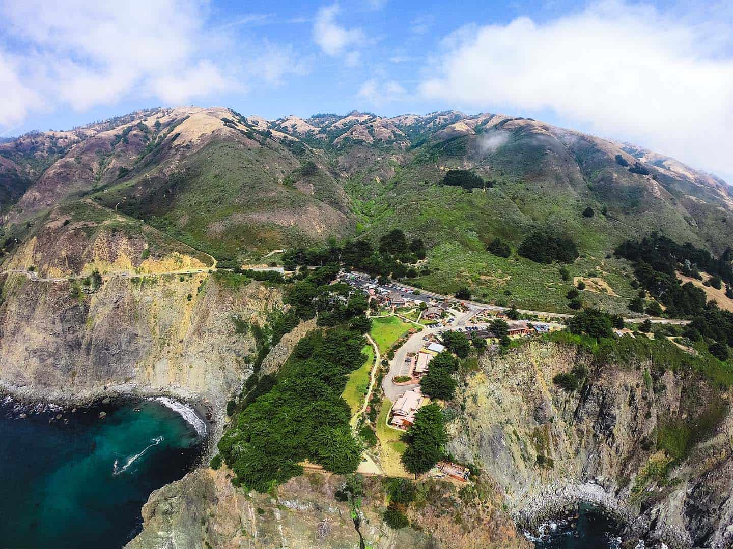
A hiker’s paradise, San Simeon and Ragged Point offer a wide variety of trails, terrain, and vistas. The hikes available around these neighboring towns span from casual to challenging, brief to long, sea level to thousands of feet in elevation. Like so many attractions along this stretch of Highway 1, hiking San Simeon and Ragged Point is easy with wide open, uncrowded trails. Pull off the road for a quick stroll or plan to take an entire day on one trail alone. Whichever option you choose, it’s sure to include a sweeping view of pristine coastline — the kind you can’t find anywhere else.
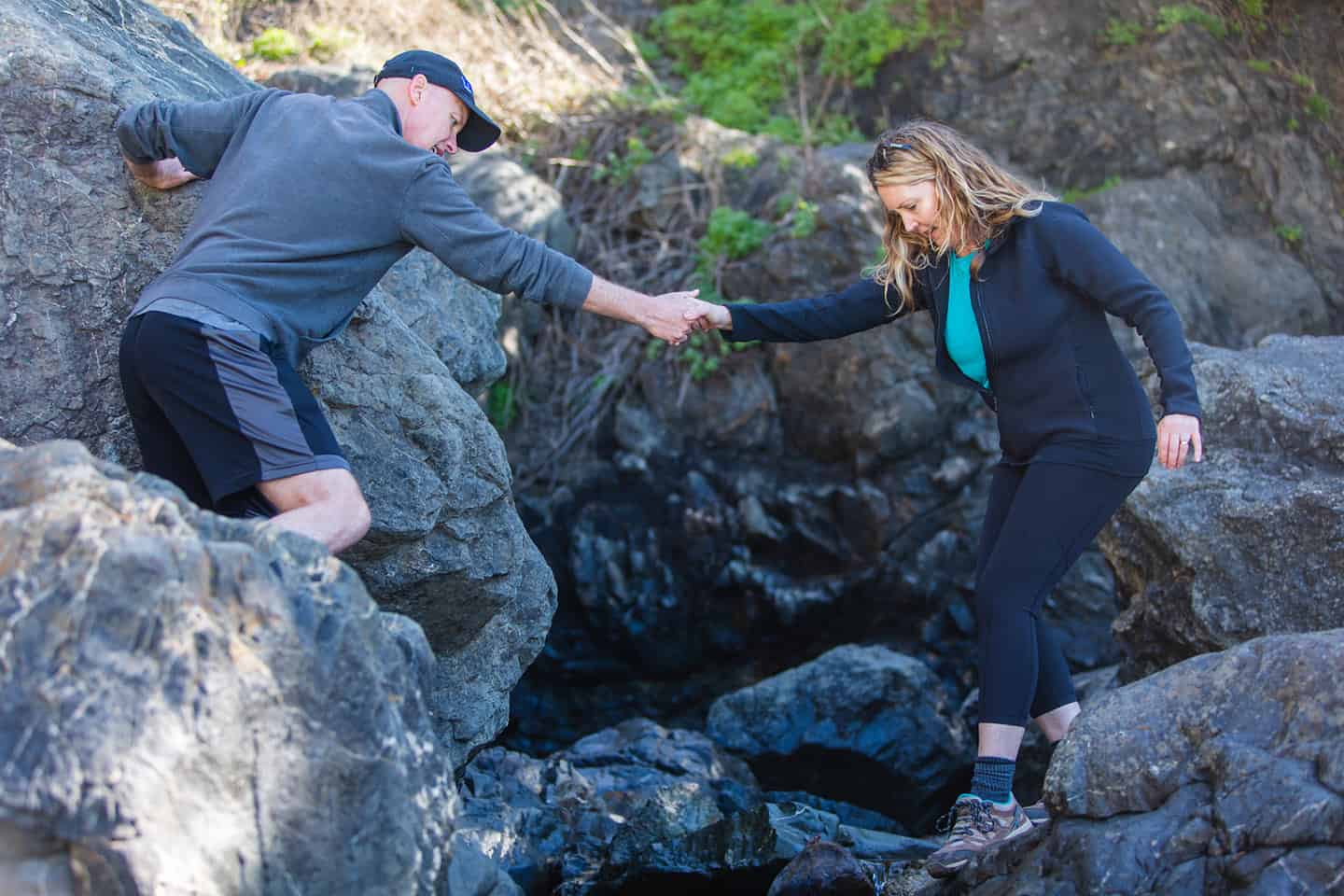
As with any hike on the Central Coast, plan ahead with a few simple strategies. The weather here can change along the trail, so be sure to dress in layers to adapt to the moment. Always bring a bottle of water, a hat and sturdy hiking shoes, and wear sunscreen. Some trails offer ideal spots for a picnic, so put local cheeses, a baguette, fresh fruit and a blanket in your backpack. If you’re a birder, whale-watcher or native plant enthusiast, you’ll want to bring your binoculars and a notebook to record your findings. Or, if you’re artistically inclined, pack watercolors, pencils, charcoal and paper into your backpack and prepare to capture the views of a lifetime.
EXPERIENCE SAN SIMEON AND RAGGED POINT HIKING
San Simeon Hiking Trails
Boucher Trail
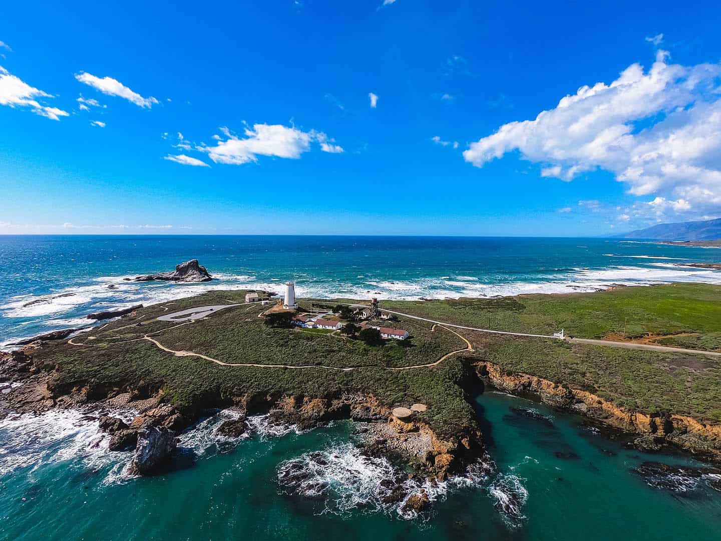
This easy out-and-back walk includes some of the finest views of the Northern Elephant Seals and the Piedras Blancas Light Station. At 3.8 miles round-trip, the Boucher Trail offers a nice distance without requiring climbing or anything too strenuous. Take a morning or afternoon stroll along this picturesque path, or tack it onto a visit to see the Elephant Seals. This trail provides several opportunities to get a good look at these magnificent creatures in their natural environment on the beach. You can also add in a docent-led tour of the Piedras Blancas Light Station, built in 1875 and still operating today. The lighthouse provides a glimpse into the history and heritage of this part of the Central Coast, midway along the trail. Access to the light station grounds is by guided tour only. At different points, the path includes wide trails, both paved and dirt, and even some sections of boardwalk.
To reach the Boucher Trailhead, drive Highway 1 46 miles north of San Luis Obispo to the main Elephant Seal Rookery parking lot. Alternatively, park a quarter mile north (the official trailhead) or even at the end of the trail, 2 miles north of that. Options other than the main Rookery parking lot will be less crowded. All parking is free in these lots.
There are two lookout spots along the Boucher Trail that provide excellent viewing of the Elephant Seals without the crowds. Look for them at 10 minutes north of the main Rookery parking lot and again 15 minutes north of that. The total time to walk the trail out and back is about 1.5 hours.
Dogs are not permitted on the Boucher trail. Also, the trail provides no restrooms or trash cans, so plan ahead accordingly.
San Simeon Point Trail
A locals’ favorite, the San Simeon Point Trail is sometimes also referred to as the Beach Trail, Cove Trail, or Pier Trail. It starts from one of the best beaches in California, W.R. Hearst Memorial Beach, and ends at a scenic coastal point. At one time, this point was to become a resort and golf course, but thanks to local advocacy, it remains untouched and open. Spend a day at the beach, kayak the bay, visit the Coastal Discovery Center, fish the pier, or even tour Hearst Castle. Then add a walk along this 2.5-mile easy roundtrip trail — or do the trail alone. Head north along the shore, then through a magical, sun-dappled forest where branches hang with lacey Spanish moss. Emerge at the point and maybe spy a migrating whale or two offshore. However you choose to do it, you’ll soon discover why media mogul W.R. Hearst once wanted this cove all to himself.
To get to the trailhead, drive 40 miles north of San Luis Obispo on Highway 1. Make a left on San Simeon Road and head to the parking lot beside W.R. Hearst Memorial Beach. Parking is free. Dogs are permitted on the trail on leash, and restrooms are available at the beach parking lot.
Junge Ranch Trail
Part of this property once belonged to the Junge family before Hearst purchased it for Hearst Ranch. In 2004, the state added it to the $95 million Hearst State Park conservation deal and it’s been open to hikers ever since. Walk over easy primitive terrain for this picturesque 2.2-mile out-and-back hike that takes in coastal bluff views and the Santa Lucia Mountains. This hike is especially stunning during the spring, when wildflowers bloom and the hills are green. Along the way, find beach access at three different places (actually highway vista stops). At the seasonal creek midway through the walk, surfers can sometimes be found waiting for waves. (This spot is called “Cardiacs” because its waves break right on the rocks. Advanced surfers only!) Fishing for shallow water fish happens in this spot, as well.
Stop for a picnic on the sand or explore the tidepools at low tide for anemones, urchins and sea stars. You can even take this trail its full length north to Hearst Memorial State Beach, just over an hour of walking without stops. Find much of Highway 1’s best beachcombing here, including sea glass, sea shells, and driftwood. Watch seals relax on the rocks, otters playing offshore, Brandt’s cormorants, and maybe even a migrating grey whale. The setting feels remote, even though Highway 1 stands just a few hundred yards away.
To reach the trailhead, Drive 37 miles north of San Luis Obispo on Highway 1. Just past the San Simeon State Campground, turn left on San Simeon Creek Road, then head north (right) on Lone Palm Drive. Park at the end of the street to start the walk. (Alternatively, park at Hearst State Beach and walk south on the Junge Ranch Trail.) The trail is dog friendly for pups on leash.
Washburn Campground Trails
This trail is known by many names: San Simeon State Park Trail, Washburn Campground Trail and San Simeon Creek Trail. Walk easy terrain for a 3.5-mile semi-loop through the Washburn Campground, part of Hearst San Simeon State Park, inland from the coast. The family-friendly trail winds through sections of the San Simeon Natural Preserve as well, taking in scenic vistas, pine groves and open wetlands. In the spring, these views also include carpets of exuberant and colorful wildflowers. Along the way, benches allow hikers to rest or grab a snack, and interpretive signs share information about the trail’s abundant wildlife. Without stops, this hike takes about 1.5 to 2 hours to complete.
To locate the trailhead, drive 38 miles north of San Luis Obispo on Highway 1/ Turn right into the Hearst San Simeon State Park. Follow signs to the Washburn Day Use Area and park near the public restrooms. Find the nearby boardwalk and follow it to the start of the trailhead, walking south and up into the pine tree forest. Don’t miss the side trail that travels over a bluff above San Simeon Creek. At the upper State Park camping area, turn left to reach the trail’s starting point, or walk further for a larger loop that makes this hike longer. Dogs are not permitted on the trail. Parking is free and restrooms are available.
Point Sierra Nevada Trail
This fairly unknown beach trail covers Point Sierra Nevada, north of San Simeon and Point Piedras Blancas, part of Hearst State Park. Find an uncrowded 2-mile round-trip trail along a narrow path, past rugged coves and onto a sandy, wide beach. Coastal wildflowers bloom alongside the dunes in spring, painting the coastline like watercolors. This trail is easy and provides some of the best beachcombing around, especially driftwood sculpted by time and the sea. When visiting at low tide, discover tide pools along the northern point of the beach, where hermit crabs skitter over the rocks. Other wildlife include sea birds, seals, and whales during migration season. At the point, this walk provides a remote and peaceful place to take in the sea air and watch the waves.
To reach Point Sierra Nevada Dunes Beach, find two pull-outs along Highway 1 north of Piedras Blancas, 9 miles north of San Simeon. Trails lead to the shore from these pullouts. At the southern entrance, be prepared to squeeze through a barbed-wire fence for more direct access. Alternatively, add a little time to your hike by using the wooden pedestrian opening at the northern trailhead entrance. Dogs are not permitted on this trail, nor are restrooms provided.
Hiking Trails Near Ragged Point
San Carpoforo Creek Trail
Short and sweet, this trail traces the southern boundary of Big Sur, making for a short, easy and scenic walk. Follow in the footsteps of the sailors on Portola’s expedition of 1769, who walked beside San Carpoforo Creek into the Santa Lucia Mountains. Here, they took advantage of fishing the steelheads that swim the creek — both then and now. In the case of the San Carpoforo Creek Trail, the path travels downstream to the ocean. This part of Highway 1 goes largely unnoticed, making it one of the best hidden gems on the coast. Starting with a narrow dirt path, follow the trail out and back for 1 mile out and back, including beach access at low tide. Along the trail, watch for Western Snowy Plover, a protected bird species that makes its home between the trailhead and the sea. Life abounds at this intersection of saltwater and freshwater, with seals, otters, and multiple seabird species. Wildflowers also grow here after the winter rains, under the warm spring sun. And, if time allows, don’t miss the opportunity to watch the sunset on the beach beside San Carpoforo Creek. The trail takes 1 hour or less to walk.
To locate the trailhead, drive 55 miles on Highway 1 north from San Luis Obispo, or 14 miles north Hearst Castle. San Carpoforo Creek is identified by a sign along the highway. Pass the sign and park on the highway’s west side, across the street from a solitary ranch house, leaving the gate accessible. Walk past the gate and follow the single-track trail down to the beach. Dogs are permitted on this trail; as this is in a remote area, restrooms are unavailable.
Black Swift Falls Trail
This difficult but rewarding trail is known by several names, including the Black Swift Falls Trail, and the Waterfall Trail. But no matter what you call it, this is a spectacularly scenic hike just south of Big Sur. Though the Black Swift Falls Trail only covers 0.8 miles out and back, it descends and then ascends 300 feet in elevation. Budget to spend about an hour for the hike. The path follows narrow and rocky switchbacks, so grippy hiking shoes are a must. At the bottom, find the payoff for all that elevation with a waterfall cascading onto a black sand beach. Due to its unusually dark color, the sand here is often warmer than anywhere else nearby. Find shorebirds here, as well as views of the steep, majestic cliffs you just descended.
To reach the trailhead, drive 15 miles north of the Hearst Castle entrance on Highway 1. Pull into the northernmost parking lot of the Ragged Point Inn and walk to the grassy area overlooking the high bluffs. Find the sign that reads “Nature Trail” for the trailhead. Restrooms are available at the inn; dogs may travel this trail on leash.
Fire Road Trail Hike
Looking for a serious challenge? This strenuous hiking trail covers 4 miles out and back, and gains 1,700 feet in elevation. For those seeking a workout, this is one of the best ascents on the Central Coast, with some of the best views. Because the ocean is almost always in view, however, hikers wanting a 30-minute trek can still experience the rewards of a quick climb. While it’s never especially steep, this trail climbs up and up the whole way, with no flats at all. Despite the elevation challenge, the trail follows a graded fire road that’s very easy to hike. At the top, find a grassy glen and gnarled old oak trees to shade a picnic or a mid-hike snooze.
This trailhead is conveniently located just across Highway 1 from Ragged Point Inn at the southern end of Los Padres National Forest. Drive 15 miles north from Hearst Castle on Highway 1 and park in the Ragged Point Inn parking lot. Crossing to the east side of the highway, look for a Forest Service sign and a gate over the fire road: this is the trailhead. Be aware that this hike doesn’t offer much shade, so plan to bring a hat, sunscreen and water at minimum. Dogs are allowed on this trail on leash.
Salmon Creek Falls
Unlike some of Big Sur’s more remote waterfalls, the 120-foot Salmon Creek waterfall is just a quarter mile from the trailhead. Experience the power and beauty of these natural falls, just a few minutes’ walk from Highway 1 through oak forests. (Note: be careful near any waterfall, as fast currents and steep cliffs can lead to injury.) True to its name, the Salmon Creek Falls trail offers miles of fishable stream to those with a fishing license. For a longer walk, follow the Salmon Creek Falls Trail 2 miles inland for the Spruce Camp. The Estrella Camp lies another 1.25 miles inland from there, as well. To hike the entire Salmon Creek Trail, be prepared for 6.5 miles out and back with an elevation gain of 1,300 feet. The trail is well maintained but rugged in places, and is moderate to difficult to hike.
Find the Salmon Creek Falls trailhead at a turnoff 3 miles north of Ragged Point on the east side of Highway 1. Park beside the ranger station; parking is free. Dogs may hike here on leash; there are no restrooms available along the trail.
Cruickshank Trail
At 6 miles long and with a gain of 1,200 feet, the Cruickshank Trail isn’t for the faint of heart. But for those willing to tackle its quiet hillsides and dense vegetation, the breathtaking views are worth the effort. Start with a set of switchbacks up the mountains into untouched wilderness, the path becoming narrower with foliage on both sides. (Sometimes this includes poison oak, so be sure to wear long sleeves and pants.) Find the Lower Cruickshank Camp 2 miles in and the Upper Cruickshank Camp just beyond that. To hike the full trail, follow signs to the Villa Creek Camp to the left, through a redwood forest. Cross a rushing creek and enjoy a snack or lunch at the Villa Creek Camp picnic area. Just a bit beyond that, find a set of quiet pools and small waterfalls among large boulders before heading back.
For the trailhead, drive 23 miles north of Hearst Castle on Highway 1. Find the sign that lists distances to the Lower and Upper Cruickshank Camps and the Villa Creek Camp. Park there and walk to the trailhead, just north of Gorda Mountain Road. Dogs are allowed on the trail; restrooms are unavailable.
Buckeye Trail
Some of the most extraordinary views in Big Sur can be found along the Buckeye Trail, in the 28,000-acre Silver Peak Wilderness. From its coastal ridges and peaks, the Pacific spreads north to south from 180-degree views. But those views come at a (moderate) price: 6.5 miles out and back, and high elevation. It travels up swiftly through oak woodlands and overgrown foliage to the Buckeye Trail Junction. Here, the Piedras Blancas Light Station is visible 15 miles to the south. In spring, find flowing streams crossing deep ravines before ascending to a bluff with unparalleled southward views. The trail also crosses a 2,200-foot bluff with views to the north, capturing yhe steep Santa Lucia Mountains as they tumble toward the sea. To finish, the trail descends to the Buckeye Camp, where a picnic table invites you to eat lunch before heading back.
The Buckeye Trail trailhead is located 3.7 miles north of the Ragged Point Inn. Just past the trail to Salmon Creek Falls, pull onto the north shoulder of Highway 1. The start of the Buckeye Trail stands beside the Salmon Creek Ranger Station. Parking is free, and dogs are permitted on the trail. Restrooms, however, are not available.
Pacific Valley Bluff Trail
This short and scenic coastal trail offers serious bang for the buck. If all you have time for is one small hike, this is a perfect and easy trail to consider. The 1-mile loop is flat and wide along grassy bluffs overlooking the ocean. In the spring, this field blooms extravagantly with coastal wildflowers. (An even more spectacular sight includes cattle grazing among them, as this is active grazing land.) Follow comfortably along the cliffs looking down to the vast Pacific Ocean, and find sea lettuce and coastal sage beside the path. There are also giant boulders to explore around, terrific for families with kids who need to get the wiggles out.
The trailhead to the Pacific Bluff Trail is easy to find about 31 miles north of Hearst Castle. Park in the pullout beside the sign that reads “Pacific Valley Station, Los Padres National Forest. Find the wooden steps a few feet north of the sign to start the hike. Parking is free, and dogs are allowed on the path; but restrooms are not available.

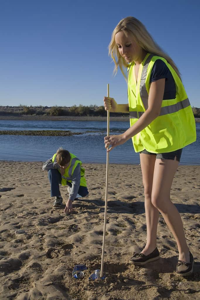
Stewardship Travel for Good
Want to learn more about this spellbinding place we call home? The Stewardship Travel for Good program brings travelers closer to the heart of the Central Coast with activities that do everyone good. If you’ve connected with San Simeon’s beaches, why not help with a beach clean-up? San Simeon State Park and W.R. Hearst Memorial Beach welcomes visitors to chip in to keep our beaches healthy. Or get hands-on with the Coastal Discovery Center through their citizen science Plankton Monitoring Program. Consider these and dozens of other bite-sized activities that do good and feel good on our special stretch of Highway 1.