In 2003, the U.S. Department of Transportation named the stretch of Highway 1 between Ragged Point and Edna Valley a National Scenic Byway. This special designation recognizes American roadways with archeological, cultural, historic, natural, recreational and/or scenic distinctions. The program exists to preserve and protect the nation’s iconic roads. As of January 2021, the Department of Transportation counts 184 National Scenic Byways. A fraction of these are called “All-American Roads,” considered the most scenic of drives; our stretch of Highway 1 is counted among them.
A straight shot of 57 miles lies between Ragged Point — also known as the Gateway to Big Sur — and Edna Valley. This scenic byway takes about one hour to drive directly, but most folks take it as a days-long road trip. This allows time for experiencing all the different towns, views, and points of interest. It is also a very do-able itinerary for avid cyclists who want to experience the All-American byway on two wheels.
A road trip across this expanse offers a wide variety of extraordinary moments to remember for a lifetime. Ocean-view adventures offer the opportunity to see a whale migrating in the distance. Hike a rugged coastal trail or a sandy mountain. Wander through a hilltop mansion or down the length of a historic pier. Shop and dine in quaint beach towns, ending the day with wine tasting in the rolling hillside vineyards of Edna Valley.
Sound like a trip through paradise? It is. Here, we highlight some of this tour’s most popular points of interest, plus hidden gems to be discovered along the way.
Explore The Scenic Byway
Gateway to Big Sur
Ragged Point is called “The Gateway to Big Sur” for good reason: it marks the beginning of that famously vast, unspoiled coastline. The gateway actually starts just north of Ragged Point Inn, a spot to relax and take in the jaw-dropping ocean views. Grab a glass of wine at the Restaurant at Ragged Point, and enjoy the scenery from their heated patio or comfortable dining room. Alternatively, pick up a cup of coffee and pastries at the outdoor Espresso Bar, or casual American fare at the Sandwich Stand. Then lounge on the lawn or wander to the “Million-Dollar View” portal, a public sculpture positioned to capture the picturesque Big Sur coastline. (The rugged cliffs and open ocean go on and on here — it all begs to be Instagrammed, so be camera-ready.) If you feel adventurous and curious, lace up your sturdy hiking shoes and take the Ragged Point Trail. The trailhead for this hike is labeled simply “Nature Trail,” which doesn’t do justice to its views, beach, and secret waterfall. Head down the short, steep path to a secluded black sand beach and enjoy sea-level views. Looking back toward the cliffs, the seasonal Black Swift Falls cascade down to meet with the ocean. Spend an hour soaking it all in before hoofing it uphill to return to the Ragged Point Inn.
San Simeon
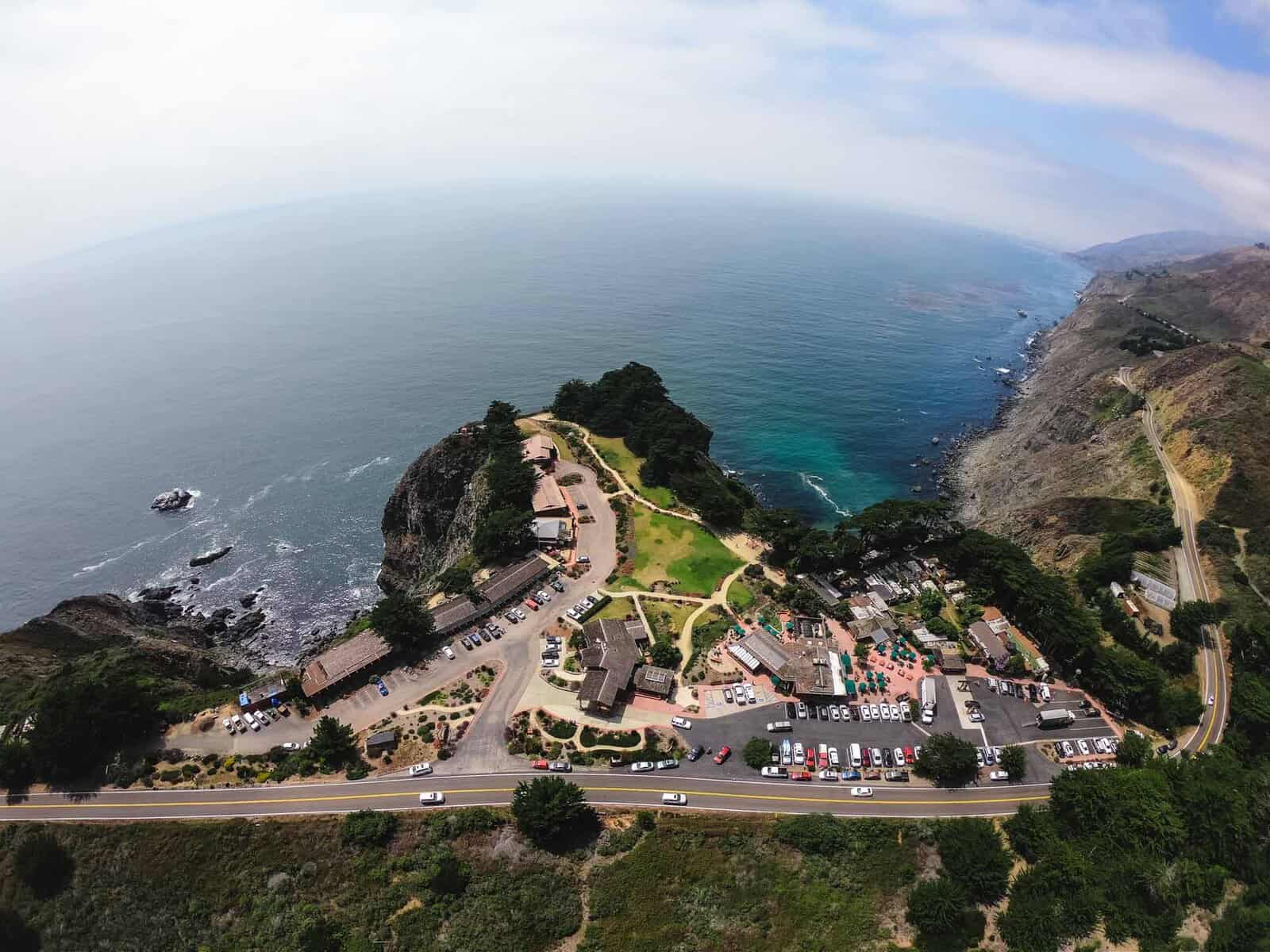
The San Simeon landscape has captured visitors’ imaginations dating back to the time of the indigenous Chumash people, millennia ago. Colored gold or green depending on the season, San Simeon’s broad hills tumble into the Pacific Ocean below. This view became a particular favorite of media magnate William Randolph Hearst, who left a lasting legacy here. His home, now called Hearst Castle, was designed by historic California architect, Julia Morgan, and built between 1919 and 1947. It rambles over 90,000 square feet of hallowed halls, once host to the who’s-who of Hollywood, Washington D.C. and beyond. Hearst was an avid collector, decorating his home with art and artifacts dating back to the time of the Egyptian pyramids. The hilltop home remains as it was in Hearst’s day, and is now open to the public as a state park. This “museum like no other” hosts multiple different kinds of tours year-round, and is a must-see for any visitor. If, however, you can’t afford to stop for a tour, keep an eye out for zebras across Hearst Ranch on the east side of Highway 1. The zebras are descendents of those that once lived in Hearst’s private zoo, and can easily be seen from the road.
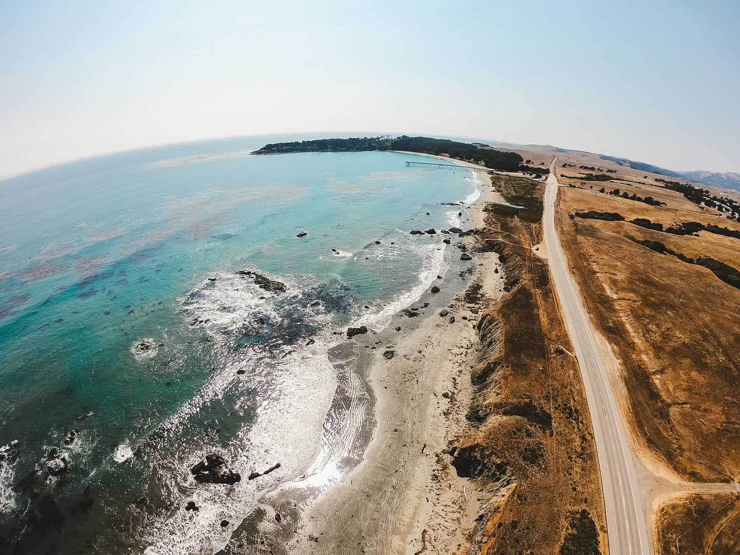
A completely different spectacle lies just west of Hearst Castle at the Piedras Blancas Elephant Seal Rookery. Great Northern Elephant Seals migrate to the beaches along this strip of shoreline to mate, give birth, and molt throughout the year. Watch the drama of life unfold from a front row seat at the rookery’s elevated boardwalk viewing area. Volunteers from the Friends of the Elephant Seal organization are available to answer questions and share their expertise about these fascinating creatures. Visit at the right time of year to witness giant males fighting for dominance or mothers pupping their young before your very eyes. This is some of the best free entertainment around — a fun and memorable experience for the whole family. While you’re there, check out the nearby Piedras Blancas Lighthouse, a historic landmark whose beacon still shines today. The lighthouse offers tours throughout the year (reservations required), led by docents knowledgeable about its significance for seafaring vessels since 1875. Access to the light station grounds is by guided tour only.
Cambria
The seaside hamlet of Cambria spans across two distinct villages connected by Main Street. While the town offers charming restaurants, boutiques, galleries and historical tours, its unspoiled coastline is not to be missed. Take Highway 1 to one of several access points to Moonstone Beach. Wander down to the shoreline, take off your shoes, and discover that the sand between your toes is actually tiny polished stones. These little beauties are “moonstones,” tumbled by sea waves for centuries to look like otherworldly gems. Spend anywhere from an hour to an entire day exploring this beach and its colorful moonstones, sea glass and driftwood. This is a family-friendly spot with wading at the Santa Rosa Creek mouth and access to the playground and restrooms at Shamel Park. Or if you’d rather appreciate the beach from afar, walk the mile-long ADA-accessible Moonstone Beach Boardwalk for relaxing sights and sounds of the ocean.
Just southwest of Cambria lies another natural wonder easily accessible from Highway 1 and open for public enjoyment. The Fiscalini Ranch Preserve was once a rancho and dairy farm that spans 434 acres of coastal forest, plains and seaside cliffs. Today, the preserve is a carefully-maintained open space with miles of trails for hiking and mountain biking. With multiple access points along the preserve’s boundaries, the network of trails can travel as near or far as you please. Take in a wooded walk through Monterey Pine trees, the forest floor soft with pine needles. Continue out to wide open coastal plains with expansive views of the ocean. From there, walk down to the shore cliffs to stroll an ADA-accessible boardwalk above the beach. Alternatively, any one of these sections can be hiked on its own from separate entrances and trailheads. But wherever you wander, you’ll find a spectacular world apart. From one of the many driftwood benches, view whales, sea birds, sea lions, and maybe even a raft of spunky sea otters. Anything can happen in this untouched natural playground.

Harmony
You read that right: the sign announcing the town of Harmony, California, says the population totals only18 people. Blink and you’ll miss this tiny town as you drive by; stop to check it out, and you’ll discover it’s big on personality. This historic hamlet once bustled with the operations of a thriving dairy cooperative that sent milk, cream and butter up and down California. As the production of these products became more centralized elsewhere, the coop closed and the town’s population dwindled to the single digits. In the meantime, glassblowers, painters, sculptors and other artists set up shop in town and turned it into a quirky stop for creatives and collectors. Today, the spirit of the Harmony Creamery has been revived, with an ice cream truck selling delicious treats made from local milk and cream. You can also visit pottery studio and glass blowing gallery to pick up unique gifts, or just to watch the artists at work. Afterward, head slightly south to the entrance of Harmony Headlands State Park. Here you’ll find a 4.5-mile roundtrip hike across a grassy plain and out to the ocean bluffs. Like many other open spaces that have been preserved along Highway 1, this was once a rancho and dairy farm. Soak in the coastal ranch landscape and history of this remarkably picturesque place. The walk is easy out to the rugged bluffs; if you’re a painter or sketch artist, this is definitely the place to set up your easel.
Cayucos
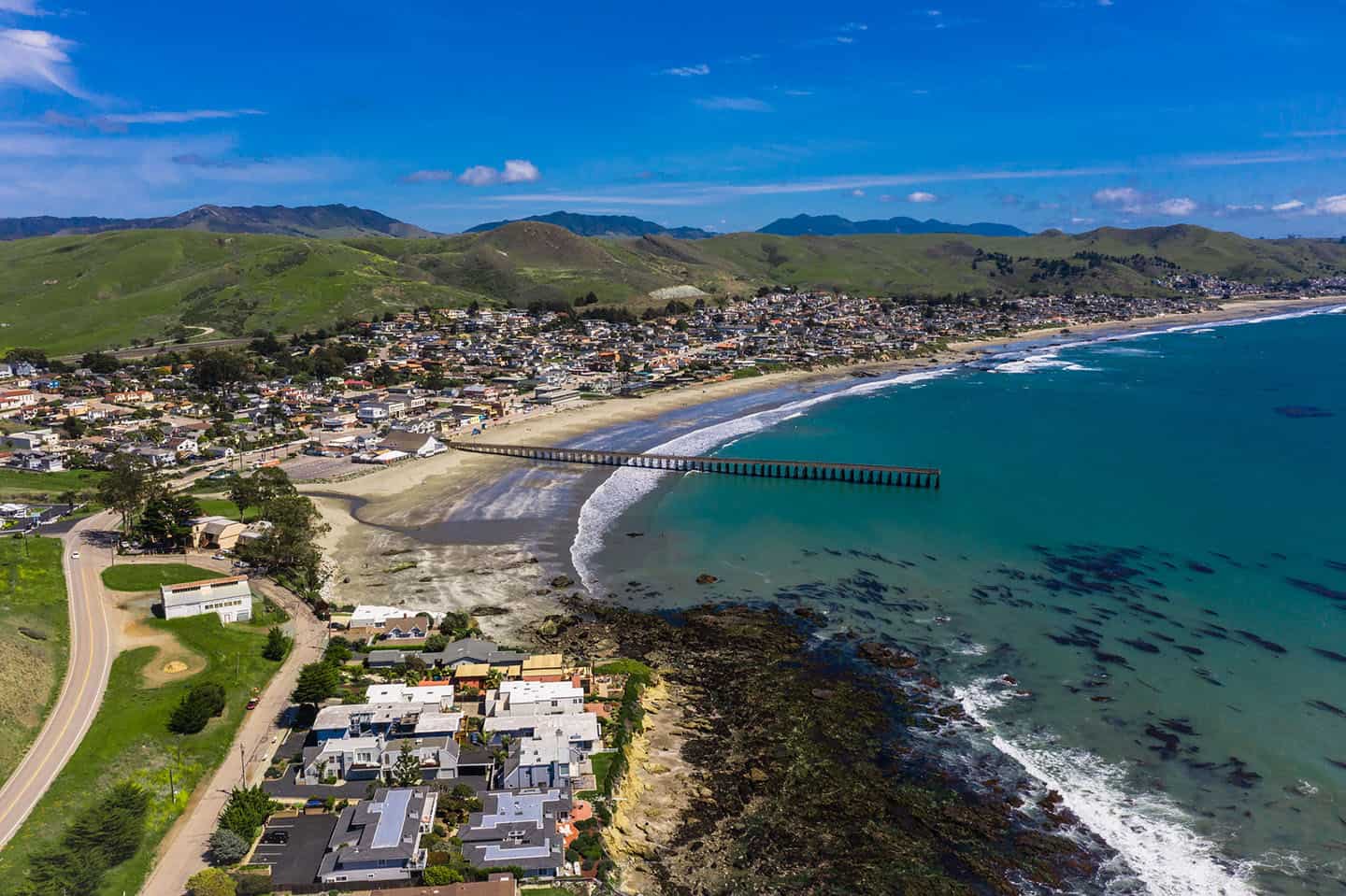
The beachy cool of this classic seaside town has appealed to generations of travelers. Everything revolves around Cayucos State Beach, the white sand beach favored by surfers, anglers, families, romantics, frisbee enthusiasts, sunbathers and sandcastle builders. And right at the heart of Cayucos State Beach lies the Cayucos Pier, a historic landmark built in 1872. Conceived by Captain James Cass, the pier functioned as a wharf for shipping and receiving to the growing coastal communities. Today, it is an anchor to the Cayucos way of life. Walk down the pier with your fishing rod and catch surf perch, cabezon and lingcod for dinner. Or stand at its end and keep your eyes peeled for a whale spout in the distance. You can also watch the surfers carve it up just south of the pier — maybe they’ll inspire you to zip up your wetsuit, too! The pier and Cayucos State Beach are kid- and family-friendly, and dog-friendly, located just beside the skate park and beach playground. Plentiful dining and shopping options are also just steps away in any direction.
A very different side of Cayucos can be seen at Estero Bluffs State Park, just north of town and accessible from several entrance points. The bluffs offer a four-mile circuit of trails that weave between Highway 1 and the shoreline. These pass beside quiet, empty beaches, tidepools hosting sea stars, anemones and crabs, and vibrant strokes of wildflowers. The path is very flat and easy, welcoming people of all ages and abilities to walk the bluffs. Ocean lovers will especially appreciate the beached fishing boat that lies just off the coastline in one cove. At low tide, visitors can even reach the boat to explore its secrets up close.
Morro Bay
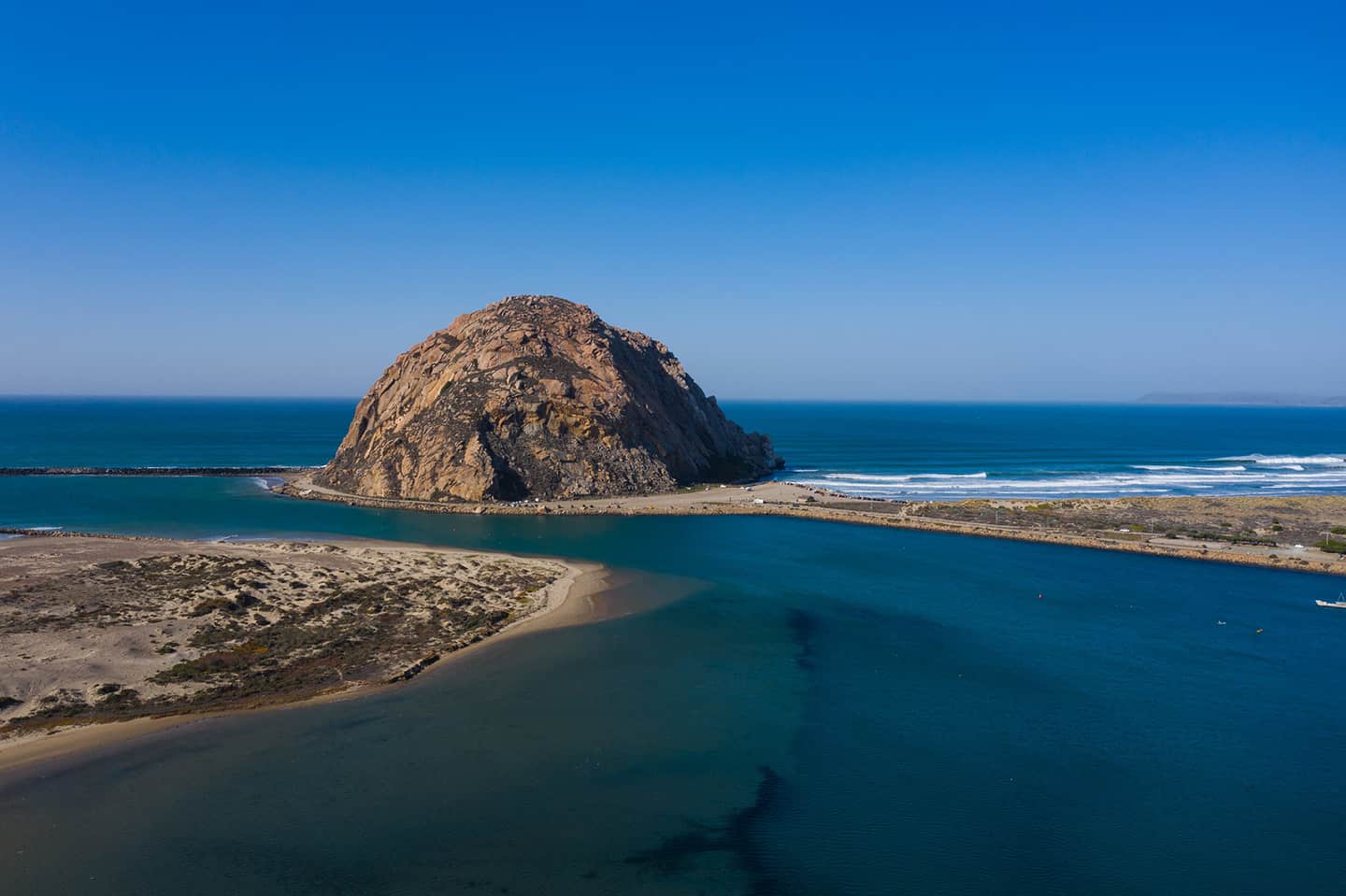
For generations, Morro Bay has delighted visitors with iconic views of Morro Rock, the inner remnant of a long-extinct volcano. Portuguese explorer Juan Rodriguez Cabrillo named the rock “El Morro” after its crown shape and dominance over the surrounding landscape. Today, Morro Rock represents the town of Morro Bay itself, which radiates out from the nearby harbor and embarcadero. Make a trip to Morro Rock Beach, at the base of this State Historic Landmark, to get up close and personal. Or rent a kayak and enjoy views of Morro Rock from out in the water. The inlet just south of Morro Rock leads to the Morro Bay National Estuary, a spectacular natural area that’s federally protected and preserved. Kayak or use a standup paddleboard (SUP) to reach the wild dunes of Sandspit Beach, the otter habitat, or oyster farms. Because the estuary lies inland from the ocean, it provides the perfect climate for paddling around, for the whole family. Low wind and no waves also make this area rich with wildlife and natural splendor — don’t miss a moment.
Los Osos Baywood Park
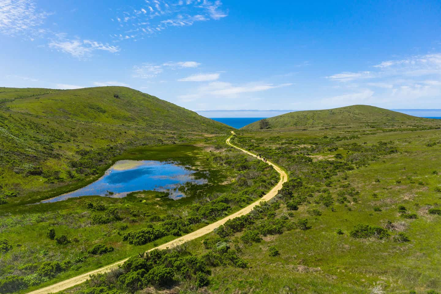
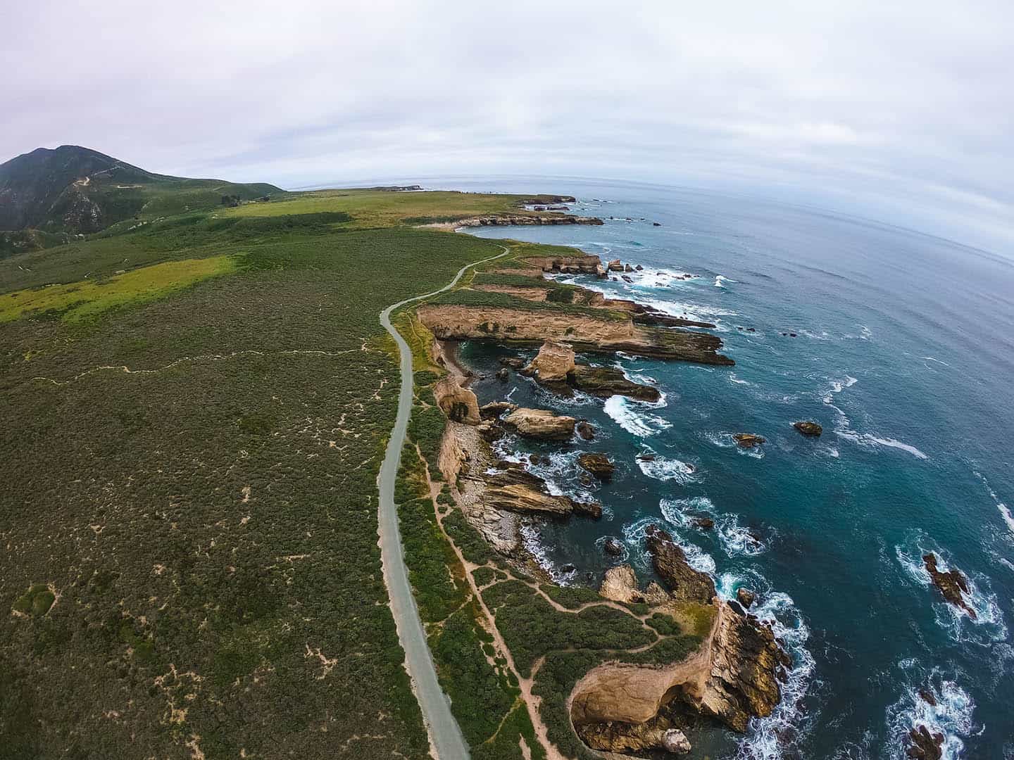
While the U.S. Department of Transportation doesn’t specifically designate Los Osos as part of the Scenic Byway, a slight detour is worthwhile. Adjacent to Morro Bay via Sandspit Beach and the Morro Bay National Estuary, Los Osos Baywood Park offers similarly remarkable natural wonders. Head to one of the most scenic hiking and cycling destinations on the Central Coast at Montana de Oro State Park. Here, the climate favors hikers and mountain bikers with cool breezes all day long across the park’s 8,000 acres of open space. Choose from ocean bluff trails to scenic mountain trails that summit at over 1,000 feet in elevation. Montana de Oro also welcomes equestrian visitors to ride horseback on trails through eucalyptus groves and over sandy Families, sunbathers, and advanced surfers love the areas near Spooner’s Cove Beach, too. For tidepooling, nothing beats a visit to Corallina Cove in Montana de Oro. Considered some of the best tidepooling along Highway 1, Corallina Cove can be accessed via the Bluff Trail. Follow the sandy path down to the shoreline and explore the thousands of pools created by shifting sedimentary rock. Find limpets, hermit crabs, anemones, sea stars, urchins, mussels, and much more in these tiny underwater worlds.
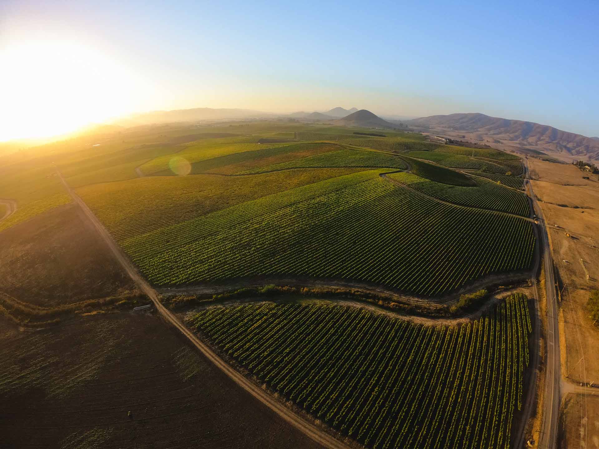
Edna Valley
Rolling hills, vineyard views, and seriously stunning wines define Edna Valley wine country, just south of San Luis Obispo. The opportunities for wine tasting excursions are nearly endless, with small and large wineries opening their doors at nearly 30 tasting rooms. Chardonnay and pinot noir, among other varieties, thrive in the coastal climate here, which has one of the longest growing seasons in California. Most wineries are boutique family affairs where the owner is very possibly the person pouring your tastings. Edna Valley is regularly named by wine media as one of the best under-the-radar wine country regions in the country. Visit one tasting room or visit a few; bring a designated driver or hire a wine tasting tour. Don’t miss a visit to the Old Edna Townsite and the Sextant Winery gourmet deli for snacks, lunch and wine tasting. It’s the perfect way to end a long journey along the byway before settling into one of many available lodging opportunities.
If you’re up for one more destination on this itinerary, hit the Lopez Lake Recreation Area just south of Edna Valley wine country. Here, you can cool off with swimming and jet skiing on the lake, or kayaking, boating and fishing for bass, in season. This is an area popular for hiking, mountain biking and horseback riding as well. Check in at the water slides and enjoy wet and wild fun in the sun for the whole family. Or head to the outdoor adventure park for ropes courses, ziplining over the lake, and more. Fun is the name of the game in this state recreation area, where the marina restaurant and full bar offer specials every day. You can also rent boats, jet skis, canoes, and other vessels here, too. Not ready for the road trip to end? This may be the end of the byway, but you can easily spend a whole day enjoying Lopez Lake. As with any destination on this itinerary, take a little or a lot: either way, you’ll make memories to last a lifetime.